Agence France-PresseJun 02, 2021 14:47:21 IST
The weather phenomenon La Nina has ended its latest cycle, the UN’s World Meteorological Organization said Tuesday, predicting warmer temperatures would follow in the northern hemisphere. La Nina refers to the large-scale cooling of surface temperatures in the central and eastern equatorial Pacific Ocean, occurring every two to seven years. The effect has widespread impacts on weather around the world — typically the opposite impacts to the El Nino phenomenon, which has a warming influence on global temperatures.

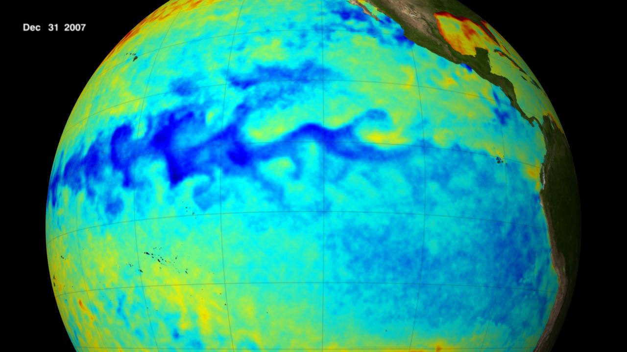
The blue area throughout the centre of this image shows the cool sea surface temperature along the equator in the Pacific Ocean during this La Niña episode. Credit: NASA/Goddard’s Scientific Visualization Studio
But La Nina’s temporary global cooling effects were not enough to prevent 2020 from being one of the three warmest years on record.
“All naturally-occurring climate events now take place in the context of human-induced climate change, which is increasing global temperatures, exacerbating extreme weather and impacting seasonal rainfall patterns,” said the WMO.
La Nina conditions have been in place since August-September 2020, according to atmospheric and oceanic indicators.
The phenomenon appeared to have peaked in October-November as a moderate strength event.
La Nina “ended in May”, the WMO said, adding that neutral conditions — meaning neither El Nino or La Nina being in effect — are likely to dominate the tropical Pacific in the next few months.
There is a 78 percent chance of neutral conditions in the tropical Pacific until July, decreasing to 55 percent by August-October, said the WMO.
False sense of security
The WMO said air temperatures over land were forecast to be warmer than average from June to August “over almost the whole northern hemisphere”.
This is due to the end of La Nina and widespread above average sea-surface temperatures caused by to global warming.
“La Nina has a temporary global cooling effect, which is typically strongest in the second year of the event. This means that 2021 has got off to a relatively cool start — by recent standards,” said WMO Secretary-General Petteri Taalas.
“This should not lull us into a false sense of security that there is a pause in climate change.”
The Mauna Loa Observatory in Hawaii is used as a benchmark reference station for measuring carbon dioxide levels.
The monthly average for April was 419.5 parts per million, up from 416.45 ppm in April 2020.
“Carbon dioxide concentrations remain at record high levels and so will continue to drive global warming,” said Taalas.
“There is a 90 percent likelihood of at least one year between 2021-2025 becoming the warmest on record.
“This would dislodge 2016 —a strong El Nino year — from the top ranking.”
Busy hurricane season ahead
1 June marks the start of the annual Atlantic hurricane season, which runs until to 30 November.
Last year saw a record-breaking Atlantic season, with 30 named tropical storms, including 13 hurricanes and six major hurricanes.
WMO spokeswoman Clare Nullis said that another above-normal season is expected this year, given that El Nino, which tends to suppress hurricane activity, is absent.
The US National Oceanic and Atmospheric Administration is predicting 13-20 named storms this year, of which between six and 10 could become hurricanes. As many as five of those could become major hurricanes.
The 2020 Atlantic storms led to at least 400 fatalities and cost $41 billion in damages.


